
Make a donation
Gear up for your next adventure:
As an Amazon Associate, this site earns from qualifying purchases at no extra cost to you.
Widow Mountain topographic map
Click on the map to display elevation.
Make a donation
Gear up for your next adventure:
As an Amazon Associate, this site earns from qualifying purchases at no extra cost to you.
About this map
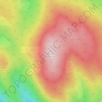
Name: Widow Mountain topographic map, elevation, terrain.
Location: Widow Mountain, Lassen County, California, United States (41.15958 -121.29692 41.15968 -121.29682)
Average elevation: 5,781 ft
Minimum elevation: 4,938 ft
Maximum elevation: 6,302 ft
Make a donation
Gear up for your next adventure:
As an Amazon Associate, this site earns from qualifying purchases at no extra cost to you.
Other topographic maps
Click on a map to view its topography, its elevation and its terrain.
Herlong
United States > California > Lassen County > Herlong
Herlong is a census-designated place in Lassen County, California, United States. Herlong is located at the extreme eastern edge of the Sierra Nevada Mountain Range in the southeastern region of Honey Lake Valley, 8 miles (13 km) north of Doyle, at an elevation of 4,114 feet (1,254 m). Its population is 237 as…
Average elevation: 4,111 ft