
Make a donation
Gear up for your next adventure:
As an Amazon Associate, this site earns from qualifying purchases at no extra cost to you.
Navajo Lake topographic map
Click on the map to display elevation.
Make a donation
Gear up for your next adventure:
As an Amazon Associate, this site earns from qualifying purchases at no extra cost to you.
About this map
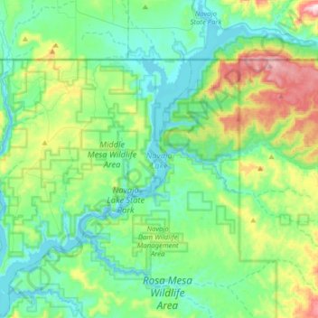
Name: Navajo Lake topographic map, elevation, terrain.
Location: Navajo Lake, San Juan County, New Mexico, United States (36.79629 -107.62007 37.04654 -107.35399)
Average elevation: 6,470 ft
Minimum elevation: 6,056 ft
Maximum elevation: 7,802 ft
San Juan County trails, hiking, mountain biking, running and outdoor activities
Make a donation
Gear up for your next adventure:
As an Amazon Associate, this site earns from qualifying purchases at no extra cost to you.
Other topographic maps
Click on a map to view its topography, its elevation and its terrain.
El Paso Natural Gas Dam Number 5
United States > New Mexico > San Juan County > Kirtland
Average elevation: 5,262 ft
Make a donation
Gear up for your next adventure:
As an Amazon Associate, this site earns from qualifying purchases at no extra cost to you.
Make a donation
Gear up for your next adventure:
As an Amazon Associate, this site earns from qualifying purchases at no extra cost to you.