
Make a donation
Gear up for your next adventure:
As an Amazon Associate, this site earns from qualifying purchases at no extra cost to you.
Crofts Corners topographic map
Click on the map to display elevation.
Make a donation
Gear up for your next adventure:
As an Amazon Associate, this site earns from qualifying purchases at no extra cost to you.
About this map
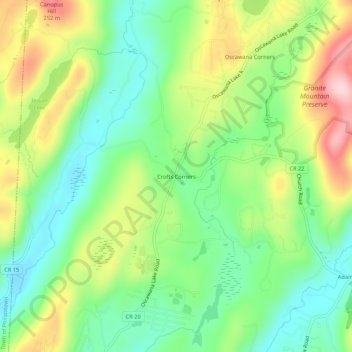
Name: Crofts Corners topographic map, elevation, terrain.
Average elevation: 463 ft
Minimum elevation: 174 ft
Maximum elevation: 919 ft
Putnam County trails, hiking, mountain biking, running and outdoor activities
Make a donation
Gear up for your next adventure:
As an Amazon Associate, this site earns from qualifying purchases at no extra cost to you.
Other topographic maps
Click on a map to view its topography, its elevation and its terrain.
Kent Cliffs Unit
United States > New York > Putnam County > Town of Putnam Valley > Richardsville
Average elevation: 886 ft
Stillwater Pond
United States > New York > Putnam County > Town of Putnam Valley
Average elevation: 945 ft
Clarence Fahnestock Memorial State Park
United States > New York > Putnam County > Town of Putnam Valley
Average elevation: 679 ft