
Make a donation
Gear up for your next adventure:
As an Amazon Associate, this site earns from qualifying purchases at no extra cost to you.
Schlesen topographic map
Click on the map to display elevation.
Make a donation
Gear up for your next adventure:
As an Amazon Associate, this site earns from qualifying purchases at no extra cost to you.
Schlesen
Blasonierung: „Von Silber und Blau im Verhältnis 2 :1 geteilt. Oben ein rotes Schulhaus in neugotischem Stil mit gestuftem Mittelrisalit über dem Eingang und jeweils vier Fenstern zu beiden Seiten; über dem Mittelrisalit ein Dachreiter mit spitzem Turmhelm, an den Stirnseiten des Daches in Traufen- und Firsthöhe je ein spitzes, bedachtes Türmchen. Unten zwei silberne Wellenbalken.“
Make a donation
Gear up for your next adventure:
As an Amazon Associate, this site earns from qualifying purchases at no extra cost to you.
About this map
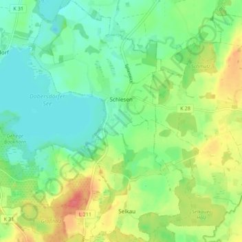
Name: Schlesen topographic map, elevation, terrain.
Average elevation: 112 ft
Minimum elevation: 43 ft
Maximum elevation: 226 ft
Make a donation
Gear up for your next adventure:
As an Amazon Associate, this site earns from qualifying purchases at no extra cost to you.