Geolocate

MEKARSARI topographic map

Click on the map to display elevation.

About this map

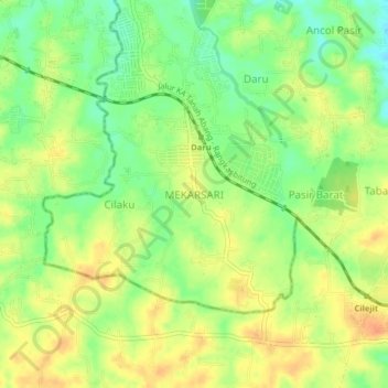
Name: MEKARSARI topographic map, elevation, terrain.

Location: MEKARSARI, Tangerang Regency, Banten, Indonesia (-6.36388 106.47183 -6.32388 106.51183)

Average elevation: 171 ft

Minimum elevation: 102 ft

Maximum elevation: 226 ft

Gear up for your next adventure:

🚁Photography Drones - Capture stunning aerial views of landforms and topography
🩳Quick‑Dry Hiking Shorts - Comfortable and quick‑dry shorts for summer hiking
🥩Freeze-Dried Meals - Nutritious and lightweight food for remote expeditions
🪶Wildlife Field Guides - Learn animal tracking and species ID
🔦Powerful Headlamps - Ultra-bright hands-free lighting for night navigation

As an Amazon Associate, this site earns from qualifying purchases at no extra cost to you.