
Make a donation
Gear up for your next adventure:
As an Amazon Associate, this site earns from qualifying purchases at no extra cost to you.
Bechar topographic map
Click on the map to display elevation.
Make a donation
Gear up for your next adventure:
As an Amazon Associate, this site earns from qualifying purchases at no extra cost to you.
Bechar
Béchar lies at an elevation of 747 metres (2,451 ft) on the banks of Oued Béchar, which runs through the city from northeast to southwest. The rocky highlands of the Djebel Béchar overlook the city from the southeast, reaching 1,206 metres (3,957 ft) to the east of the city. Further to the northeast the Djebel Antar range rises even higher, to 1,953 metres (6,407 ft). The northwest, by contrast, is a flat rocky reg.
Make a donation
Gear up for your next adventure:
As an Amazon Associate, this site earns from qualifying purchases at no extra cost to you.
About this map
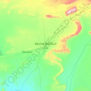
Name: Bechar topographic map, elevation, terrain.
Location: Bechar, Da'ira Bechar, Bechar, 08000, Algeria (31.18327 -2.40547 32.04856 -1.35362)
Average elevation: 2,657 ft
Minimum elevation: 1,886 ft
Maximum elevation: 6,391 ft
Make a donation
Gear up for your next adventure:
As an Amazon Associate, this site earns from qualifying purchases at no extra cost to you.
Other topographic maps
Click on a map to view its topography, its elevation and its terrain.