
Make a donation
Gear up for your next adventure:
As an Amazon Associate, this site earns from qualifying purchases at no extra cost to you.
Segaria topographic map
Click on the map to display elevation.
Make a donation
Gear up for your next adventure:
As an Amazon Associate, this site earns from qualifying purchases at no extra cost to you.
About this map
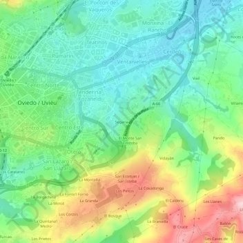
Name: Segaria topographic map, elevation, terrain.
Average elevation: 807 ft
Minimum elevation: 541 ft
Maximum elevation: 1,319 ft
Make a donation
Gear up for your next adventure:
As an Amazon Associate, this site earns from qualifying purchases at no extra cost to you.
Other topographic maps
Click on a map to view its topography, its elevation and its terrain.
Brañes
El lugar de Brañes se sitúa a una altitud de 200 metros y dista 7,7 km de la ciudad de Oviedo, capital municipal. En el año 2015 tenía una población de 28 habitantes (INE), de poblamiento diseminado, de los que 14 son mujeres y 14 son hombres.. En el año 2000 fue nombrado pueblo ejemplar por el…
Average elevation: 719 ft
Make a donation
Gear up for your next adventure:
As an Amazon Associate, this site earns from qualifying purchases at no extra cost to you.