
Marble Ridge Station topographic map
Click on the map to display elevation.
About this map
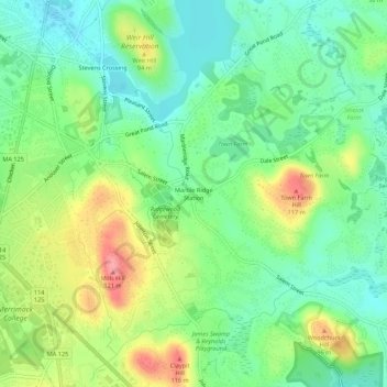
Name: Marble Ridge Station topographic map, elevation, terrain.
Average elevation: 207 ft
Minimum elevation: 92 ft
Maximum elevation: 397 ft
Other topographic maps
Click on a map to view its topography, its elevation and its terrain.
Boxford
United States > Massachusetts > Essex County
Boxford is divided into Boxford Village (commonly called East Boxford) and West Boxford Village, corresponding to the respective East and West Boxford centers. It is heavily forested and criss-crossed by various streams and brooks, many of which empty into the Ipswich River on Boxford's southern border. A…
Average elevation: 115 ft
Haverhill
United States > Massachusetts > Essex County
According to the United States Census Bureau, the city has a total area of 35.6 square miles (92.3 km2), of which 33.0 square miles (85.4 km2) is land and 2.7 square miles (6.9 km2), or 7.47%, is water. The city ranks 60th in the Commonwealth in terms of land area, and is the largest city or town in Essex…
Average elevation: 128 ft
Topsfield
United States > Massachusetts > Essex County
According to the United States Census Bureau, Topsfield has a total area of 12.8 square miles (33.2 km2), of which 11.9 square miles (30.9 km2) are land and 0.89 square miles (2.3 km2), or 7.00%, is water. Topsfield lies in the geographic center of Essex County, Massachusetts. Like its namesake in Essex,…
Average elevation: 79 ft
Danvers
United States > Massachusetts > Essex County
Though being at sea level in the Danversport area, the town has numerous hills reaching around 130 to 180 feet in elevation, including Dales Hill (located at St. John's Preparatory School), Ferncroft Hill, Folly Hill, Hathorne Hill, Lindall Hill, Nichols Hill, Putnam Hill, Rocky Hill and Whipple Hill (part of…
Average elevation: 72 ft
Blackwater River
United States > Massachusetts > Essex County > Salisbury > Salisbury Beach
Average elevation: 13 ft
Amesbury
United States > Massachusetts > Essex County
Amesbury is located at 42°51′29″N 70°55′50″W / 42.85806°N 70.93056°W / 42.85806; -70.93056. According to the United States Census Bureau, the city has a total area of 13.7 square miles (35.5 km2), of which 12.3 square miles (31.8 km2) is land and 1.5 square miles (3.8 km2), or 10.65%, is…
Average elevation: 82 ft
Danvers
United States > Massachusetts > Essex County
Though being at sea level in the Danversport area, the town has numerous hills reaching around 130 to 180 feet in elevation, including Dales Hill (located at St. John's Preparatory School), Ferncroft Hill, Folly Hill, Hathorne Hill, Lindall Hill, Nichols Hill, Putnam Hill, Rocky Hill and Whipple Hill (part of…
Average elevation: 75 ft
Hamilton
United States > Massachusetts > Essex County
According to the United States Census Bureau, the town has a total area of 14.9 square miles (38.6 km2), of which 14.2 square miles (36.7 km2) is land and 0.73 square miles (1.9 km2), or 4.89%, is water. Hamilton lies 5 miles (8 km) inland from Massachusetts Bay, and both the eastern and western portion of…
Average elevation: 62 ft
Haverhill
United States > Massachusetts > Essex County
According to the United States Census Bureau, the city has a total area of 35.6 square miles (92.3 km2), of which 33.0 square miles (85.4 km2) is land and 2.7 square miles (6.9 km2), or 7.47%, is water. The city ranks 60th in the Commonwealth in terms of land area, and is the largest city or town in Essex…
Average elevation: 128 ft
Topsfield
United States > Massachusetts > Essex County
According to the United States Census Bureau, Topsfield has a total area of 12.8 square miles (33.2 km2), of which 11.9 square miles (30.9 km2) are land and 0.89 square miles (2.3 km2), or 7.00%, is water. Topsfield lies in the geographic center of Essex County, Massachusetts. Like its namesake in Essex,…
Average elevation: 82 ft
Amesbury
United States > Massachusetts > Essex County
Amesbury is located at 42°51′29″N 70°55′50″W / 42.85806°N 70.93056°W / 42.85806; -70.93056. According to the United States Census Bureau, the city has a total area of 13.7 square miles (35.5 km2), of which 12.3 square miles (31.8 km2) is land and 1.5 square miles (3.8 km2), or 10.65%, is…
Average elevation: 82 ft
Haverhill
United States > Massachusetts > Essex County
According to the United States Census Bureau, the city has a total area of 35.6 square miles (92.3 km2), of which 33.0 square miles (85.4 km2) is land and 2.7 square miles (6.9 km2), or 7.47%, is water. The city ranks 60th in the Commonwealth in terms of land area, and is the largest city or town in Essex…
Average elevation: 128 ft
Boxford
United States > Massachusetts > Essex County
Boxford is divided into Boxford Village (commonly called East Boxford) and West Boxford Village, corresponding to the respective East and West Boxford centers. It is heavily forested and criss-crossed by various streams and brooks, many of which empty into the Ipswich River on Boxford's southern border. A…
Average elevation: 115 ft