
Make a donation
Gear up for your next adventure:
As an Amazon Associate, this site earns from qualifying purchases at no extra cost to you.
Kaprun topographic map
Click on the map to display elevation.
Make a donation
Gear up for your next adventure:
As an Amazon Associate, this site earns from qualifying purchases at no extra cost to you.
Kaprun
Kaprun (German pronunciation: [kaˈpruːn]) is a municipality in the Zell am See District in the province of Salzburg in Austria. Together with the neighboring city of Zell am See the town presents itself as the tourist destination and skiing area "Zell am See-Kaprun". Kaprun distinguishes itself from its larger neighbor at the lake, by offering all year access to the Kitzsteinhorn with its Top of Salzburg viewing platform at 3,029 metres (9,938 ft) altitude and its glacier ski area that is open October through May.
Make a donation
Gear up for your next adventure:
As an Amazon Associate, this site earns from qualifying purchases at no extra cost to you.
About this map
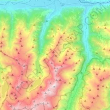
Name: Kaprun topographic map, elevation, terrain.
Location: Kaprun, Bezirk Zell am See, Salzburg, 5710, Austria (47.12070 12.66614 47.28834 12.79850)
Average elevation: 5,968 ft
Minimum elevation: 2,448 ft
Maximum elevation: 11,640 ft
Make a donation
Gear up for your next adventure:
As an Amazon Associate, this site earns from qualifying purchases at no extra cost to you.
Other topographic maps
Click on a map to view its topography, its elevation and its terrain.
Großvenediger
Austria > Salzburg > Bezirk Zell am See > Neukirchen am Großvenediger
Average elevation: 10,430 ft
Großes Wiesbachhorn
Austria > Salzburg > Bezirk Zell am See > Fusch an der Großglocknerstraße
Average elevation: 9,446 ft
Sankt Martin bei Lofer
Austria > Salzburg > Bezirk Zell am See > Gemeinde Sankt Martin bei Lofer
Average elevation: 2,995 ft
Make a donation
Gear up for your next adventure:
As an Amazon Associate, this site earns from qualifying purchases at no extra cost to you.
Hinterglemm
Austria > Salzburg > Bezirk Zell am See > Saalbach-Hinterglemm
Average elevation: 4,567 ft
Make a donation
Gear up for your next adventure:
As an Amazon Associate, this site earns from qualifying purchases at no extra cost to you.
Hohlwegen
Austria > Salzburg > Bezirk Zell am See > Saalfelden am Steinernen Meer
Average elevation: 3,629 ft
Make a donation
Gear up for your next adventure:
As an Amazon Associate, this site earns from qualifying purchases at no extra cost to you.
Strohwolln
Austria > Salzburg > Bezirk Zell am See > Sankt Martin bei Lofer
Average elevation: 3,143 ft
Make a donation
Gear up for your next adventure:
As an Amazon Associate, this site earns from qualifying purchases at no extra cost to you.
Schmalenbergham
Austria > Salzburg > Bezirk Zell am See > Saalfelden am Steinernen Meer > Thor
Average elevation: 2,572 ft
Make a donation
Gear up for your next adventure:
As an Amazon Associate, this site earns from qualifying purchases at no extra cost to you.
Königsleiten
Austria > Salzburg > Bezirk Zell am See > Gemeinde Wald im Pinzgau
Average elevation: 5,587 ft
Make a donation
Gear up for your next adventure:
As an Amazon Associate, this site earns from qualifying purchases at no extra cost to you.
Obersulzbachkees
Austria > Salzburg > Bezirk Zell am See > Marktgemeinde Neukirchen am Großvenediger
Average elevation: 9,045 ft
Make a donation
Gear up for your next adventure:
As an Amazon Associate, this site earns from qualifying purchases at no extra cost to you.
Wald im Pinzgau
Austria > Salzburg > Bezirk Zell am See > Gemeinde Wald im Pinzgau
Average elevation: 3,816 ft