Geolocate

Farlow topographic map

Click on the map to display elevation.

About this map

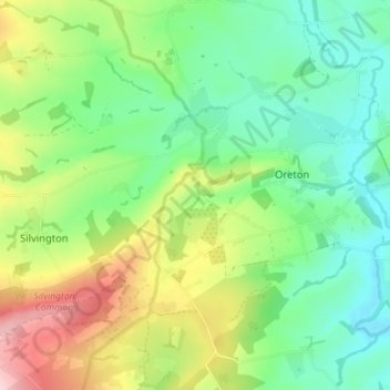
Name: Farlow topographic map, elevation, terrain.

Location: Farlow, Oreton, Shropshire, England, United Kingdom (52.40350 -2.56825 52.43654 -2.49731)

Average elevation: 636 ft

Minimum elevation: 387 ft

Maximum elevation: 1,112 ft

Gear up for your next adventure:

🛶Inflatable Kayak - Portable kayak for rivers, lakes, and expeditions
🔌Solar Panel Charger - Charge gear sustainably outdoors
🧭Outdoor Navigation Book - Learn advanced navigation skills
🧭GPS Watch Accessories - Bands and chargers for GPS watches
Camping Coffee Makers - Enjoy premium coffee at the summit or campsite

As an Amazon Associate, this site earns from qualifying purchases at no extra cost to you.