
Brainerd topographic map
Click on the map to display elevation.
About this map
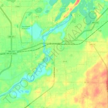
Name: Brainerd topographic map, elevation, terrain.
Location: Brainerd, Crow Wing County, Minnesota, 56401, United States (46.31263 -94.24592 46.38862 -94.14238)
Average elevation: 1,214 ft
Minimum elevation: 1,142 ft
Maximum elevation: 1,296 ft
Crow Wing County trails, hiking, mountain biking, running and outdoor activities
Other topographic maps
Click on a map to view its topography, its elevation and its terrain.
Middle Cullen Lake
United States > Minnesota > Crow Wing County > Pequot Lakes
Average elevation: 1,220 ft
Borden Lake
United States > Minnesota > Crow Wing County > Garrison Township
Average elevation: 1,289 ft