
Thank you for supporting this site ❤️
Make a donation
Make a donation
Gear up for your next adventure:
As an Amazon Associate, this site earns from qualifying purchases at no extra cost to you.
Vijagual topographic map
Click on the map to display elevation.
Thank you for supporting this site ❤️
Make a donation
Make a donation
Gear up for your next adventure:
As an Amazon Associate, this site earns from qualifying purchases at no extra cost to you.
About this map
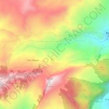
Name: Vijagual topographic map, elevation, terrain.
Location: Vijagual, Recetor, Casanare, Colombia (5.20988 -72.81002 5.23040 -72.76129)
Average elevation: 4,032 ft
Minimum elevation: 2,425 ft
Maximum elevation: 5,322 ft
Thank you for supporting this site ❤️
Make a donation
Make a donation
Gear up for your next adventure:
As an Amazon Associate, this site earns from qualifying purchases at no extra cost to you.