
Fahlenscheid topographic map
Interactive map
Click on the map to display elevation.
About this map
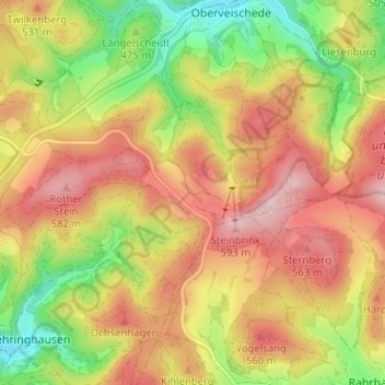
Name: Fahlenscheid topographic map, elevation, terrain.
Location: Fahlenscheid, Olpe, Kreis Olpe, Nordrhein-Westfalen, Deutschland (51.03763 7.92619 51.07763 7.96619)
Average elevation: 1,631 ft
Minimum elevation: 1,253 ft
Maximum elevation: 1,952 ft
Other topographic maps
Click on a map to view its topography, its elevation and its terrain.
Neuenkleusheim
Deutschland > Nordrhein-Westfalen > Kreis Olpe > Olpe
Neuenkleusheim, Olpe, Kreis Olpe, Nordrhein-Westfalen, Deutschland
Average elevation: 1,467 ft
Friedrichsthal
Deutschland > Nordrhein-Westfalen > Kreis Olpe > Olpe
Friedrichsthal, Olpe, Kreis Olpe, Nordrhein-Westfalen, 57462, Deutschland
Average elevation: 1,276 ft
Rhode
Deutschland > Nordrhein-Westfalen > Kreis Olpe > Olpe
Rhode, Olpe, Kreis Olpe, Nordrhein-Westfalen, 57462, Deutschland
Average elevation: 1,220 ft
Schlammborn
Deutschland > Nordrhein-Westfalen > Kreis Olpe > Olpe
Schlammborn, Olpe, Kreis Olpe, Nordrhein-Westfalen, 57462, Deutschland
Average elevation: 1,293 ft
Rüblinghausen
Deutschland > Nordrhein-Westfalen > Kreis Olpe > Olpe
Rüblinghausen, Olpe, Kreis Olpe, Nordrhein-Westfalen, 57462, Deutschland
Average elevation: 1,217 ft
Attenberg
Deutschland > Nordrhein-Westfalen > Kreis Olpe > Olpe
Attenberg, Olpe, Kreis Olpe, Nordrhein-Westfalen, 57462, Deutschland
Average elevation: 1,296 ft
Nocken
Deutschland > Nordrhein-Westfalen > Kreis Olpe > Olpe
Nocken, Olpe, Kreis Olpe, Nordrhein-Westfalen, 57462, Deutschland
Average elevation: 1,427 ft
Altenkleusheim
Deutschland > Nordrhein-Westfalen > Kreis Olpe > Olpe
Altenkleusheim, Olpe, Kreis Olpe, Nordrhein-Westfalen, Deutschland
Average elevation: 1,447 ft
Höchsten
Deutschland > Nordrhein-Westfalen > Kreis Olpe > Olpe
Höchsten, Olpe, Kreis Olpe, Nordrhein-Westfalen, 57462, Deutschland
Average elevation: 1,414 ft