
Make a donation
Gear up for your next adventure:
As an Amazon Associate, this site earns from qualifying purchases at no extra cost to you.
Neuenkleusheim topographic map
Click on the map to display elevation.
Make a donation
Gear up for your next adventure:
As an Amazon Associate, this site earns from qualifying purchases at no extra cost to you.
Neuenkleusheim
Kleusheim liegt westlich der Wasserscheide von Bigge-Sieg bzw. Bigge-Lenne. Dieser Höhenzug war bis 1814 zugleich Landesgrenze des Herzogtums Westfalen gegenüber Nassau-Siegen. Diese Grenze, das „Kölsche-Heck“, bildete somit eine Landes-, Religions- und Sprachgrenze. Die Bigge-Lenne-Wasserscheide trennt im Weiteren das Kirchspiel Kleusheim von der Pfarrei Rahrbach. Jedes der drei Dörfer liegt in einem eigenen Tal. Altenkleusheim wird von Neuenkleusheim durch einen Höhenzug, gebildet aus Stübelhagen (499 m), Eichhagen und Hohenhagen (482 m), getrennt. Rehringhausen liegt weiter nördlich und wird von Neuenkleusheim durch den Kruberg (505 m), Engelsberg (588 m) und Hesselberg getrennt. Geografisch liegt Kleusheim im Olper Hügelland das geologisch den Devonformationen angehört.
Make a donation
Gear up for your next adventure:
As an Amazon Associate, this site earns from qualifying purchases at no extra cost to you.
About this map
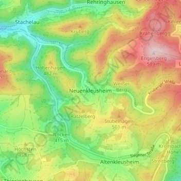
Name: Neuenkleusheim topographic map, elevation, terrain.
Average elevation: 1,467 ft
Minimum elevation: 1,099 ft
Maximum elevation: 1,913 ft
Make a donation
Gear up for your next adventure:
As an Amazon Associate, this site earns from qualifying purchases at no extra cost to you.
Other topographic maps
Click on a map to view its topography, its elevation and its terrain.