
Make a donation
Gear up for your next adventure:
As an Amazon Associate, this site earns from qualifying purchases at no extra cost to you.
Günsterode topographic map
Click on the map to display elevation.
Make a donation
Gear up for your next adventure:
As an Amazon Associate, this site earns from qualifying purchases at no extra cost to you.
Günsterode
Günsterode liegt etwa 9,5 km (Luftlinie) nordöstlich des Zentrums der Melsunger Kernstadt im Melsunger Bergland. Es befindet sich unterhalb von Himmelsberg (563,7 m ü. NN) im Nordosten und Pentersrück (562,2 m) im Osten, den höchsten Erhebungen der bewaldeten Günsteröder Höhe. Das Dorf wird vom Kehrenbach-Zufluss Ohebach durchflossen. Durch die Ortschaft führt die Landesstraße 3147 (Hessisch Lichtenau–Günsterode–Kirchhof–Melsungen).
Make a donation
Gear up for your next adventure:
As an Amazon Associate, this site earns from qualifying purchases at no extra cost to you.
About this map
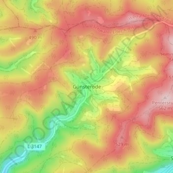
Name: Günsterode topographic map, elevation, terrain.
Location: Günsterode, Melsungen, Schwalm-Eder-Kreis, Hessen, Deutschland (51.14942 9.64038 51.18942 9.68038)
Average elevation: 1,437 ft
Minimum elevation: 915 ft
Maximum elevation: 1,837 ft
Make a donation
Gear up for your next adventure:
As an Amazon Associate, this site earns from qualifying purchases at no extra cost to you.