
Make a donation
Gear up for your next adventure:
As an Amazon Associate, this site earns from qualifying purchases at no extra cost to you.
Les Cours topographic map
Click on the map to display elevation.
Make a donation
Gear up for your next adventure:
As an Amazon Associate, this site earns from qualifying purchases at no extra cost to you.
About this map
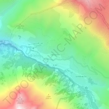
Name: Les Cours topographic map, elevation, terrain.
Average elevation: 6,660 ft
Minimum elevation: 4,843 ft
Maximum elevation: 9,852 ft
Make a donation
Gear up for your next adventure:
As an Amazon Associate, this site earns from qualifying purchases at no extra cost to you.
Other topographic maps
Click on a map to view its topography, its elevation and its terrain.
Glacier d'Arsine
France > Provence-Alpes-Côte d'Azur > Hautes-Alpes > Villar-d'Arêne
Average elevation: 9,354 ft
Glacier de la Plate des Agneaux
France > Provence-Alpes-Côte d'Azur > Hautes-Alpes > Villar-d'Arêne
Average elevation: 9,649 ft
Jardin botanique alpin du Lautaret
France > Provence-Alpes-Côte d'Azur > Hautes-Alpes > Villar-d'Arêne
Le jardin botanique du col du Lautaret est un jardin botanique alpin d'altitude (2 100 mètres) du massif alpin, situé au col du Lautaret, sur le territoire de la commune de Villar-d'Arêne, dans le département français des Hautes-Alpes. Il est l'un des plus anciens jardins botaniques alpins d'Europe.
Average elevation: 7,142 ft