
Make a donation
Gear up for your next adventure:
As an Amazon Associate, this site earns from qualifying purchases at no extra cost to you.
Brussels topographic map
Click on the map to display elevation.
Make a donation
Gear up for your next adventure:
As an Amazon Associate, this site earns from qualifying purchases at no extra cost to you.
About this map
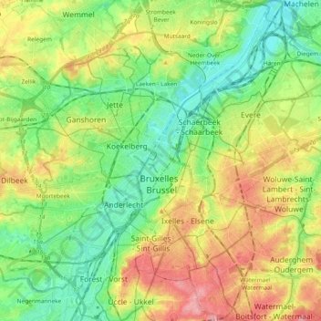
Name: Brussels topographic map, elevation, terrain.
Location: Brussels, Brussels-Capital, Belgium (50.79641 4.31400 50.91390 4.43707)
Average elevation: 174 ft
Minimum elevation: 30 ft
Maximum elevation: 397 ft
Make a donation
Gear up for your next adventure:
As an Amazon Associate, this site earns from qualifying purchases at no extra cost to you.
Other topographic maps
Click on a map to view its topography, its elevation and its terrain.
Woluwe Park
Belgium > Brussels-Capital > Woluwe-Saint-Pierre - Sint-Pieters-Woluwe
Average elevation: 240 ft
Make a donation
Gear up for your next adventure:
As an Amazon Associate, this site earns from qualifying purchases at no extra cost to you.
Make a donation
Gear up for your next adventure:
As an Amazon Associate, this site earns from qualifying purchases at no extra cost to you.
Boitsfort - Bosvoorde
Belgium > Brussels-Capital > Watermael-Boitsfort - Watermaal-Bosvoorde
Average elevation: 315 ft
Molenbeek-Saint-Jean - Sint-Jans-Molenbeek
Belgium > Brussels-Capital > Molenbeek-Saint-Jean - Sint-Jans-Molenbeek
Average elevation: 154 ft
Parc de Laeken - Park van Laken
Belgium > Brussels-Capital > Brussels > Laeken - Laken
Average elevation: 154 ft
Make a donation
Gear up for your next adventure:
As an Amazon Associate, this site earns from qualifying purchases at no extra cost to you.