Geolocate

Bridgewater topographic map

Click on the map to display elevation.

About this map

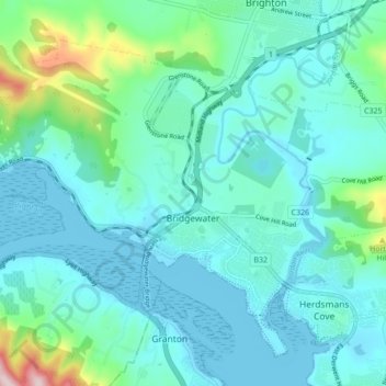
Name: Bridgewater topographic map, elevation, terrain.

Location: Bridgewater, Hobart, Brighton, Tasmania, 7030, Australia (-42.75750 147.17928 -42.70382 147.26518)

Average elevation: 187 ft

Minimum elevation: -7 ft

Maximum elevation: 1,171 ft

Other topographic maps

Click on a map to view its topography, its elevation and its terrain.

Flagstaff Hill

Australia > Tasmania > Hobart

Average elevation: 669 ft

Selfs Point

Australia > Tasmania > Hobart

Average elevation: 56 ft

Waterworks Reserve

Australia > Tasmania > Hobart

Average elevation: 787 ft

James Austin Park

Australia > Tasmania > Hobart

Average elevation: 82 ft

Perrins Ridge

Australia > Tasmania > Hobart

Average elevation: 1,532 ft

Cartwright Point

Australia > Tasmania > Hobart

Average elevation: 194 ft

Mount Direction

Australia > Tasmania > Hobart

Average elevation: 545 ft

Glebe Hill

Australia > Tasmania > Hobart

Average elevation: 217 ft

Knocklofty

Australia > Tasmania > Hobart

Average elevation: 607 ft

Snug Falls

Australia > Tasmania > Hobart > Snug

Average elevation: 1,102 ft

Tolosa Park

Australia > Tasmania > Hobart

Average elevation: 597 ft

Glenrose Park

Australia > Tasmania > Hobart

Average elevation: 594 ft

Gear up for your next adventure:

🌡️Handheld Weather Meters - Measure wind, temp, and pressure for safe mountain travel
🔦LED Headlamp - Bright and durable LED headlamp for night navigation
🧺Microfiber Travel Towels - Compact and fast-drying towels for trail use
🧤Tactile Hiking Gloves - Keep hands warm while operating GPS and smartphone screens
🪵Folding Camp Saw - Compact saw for wood and campsite work

As an Amazon Associate, this site earns from qualifying purchases at no extra cost to you.