
Make a donation
Gear up for your next adventure:
As an Amazon Associate, this site earns from qualifying purchases at no extra cost to you.
Janesville topographic map
Click on the map to display elevation.
Make a donation
Gear up for your next adventure:
As an Amazon Associate, this site earns from qualifying purchases at no extra cost to you.
Janesville
Janesville (also known as Lassen) is a sparsely populated census-designated place in Lassen County, California. It is located 11 miles (18 km) southeast of Susanville, at an elevation of 4239 feet (1292 m). Janesville is located on the eastern slopes of the Sierra Nevada Mountain range. Its population is 2,461 as of the 2020 census, up from 1,408 from the 2010 census.
Make a donation
Gear up for your next adventure:
As an Amazon Associate, this site earns from qualifying purchases at no extra cost to you.
About this map
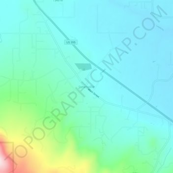
Name: Janesville topographic map, elevation, terrain.
Average elevation: 4,370 ft
Minimum elevation: 4,114 ft
Maximum elevation: 5,489 ft
Lassen County trails, hiking, mountain biking, running and outdoor activities
Make a donation
Gear up for your next adventure:
As an Amazon Associate, this site earns from qualifying purchases at no extra cost to you.
Other topographic maps
Click on a map to view its topography, its elevation and its terrain.