
Make a donation
Gear up for your next adventure:
As an Amazon Associate, this site earns from qualifying purchases at no extra cost to you.
General Pueyrredón topographic map
Click on the map to display elevation.
Make a donation
Gear up for your next adventure:
As an Amazon Associate, this site earns from qualifying purchases at no extra cost to you.
About this map
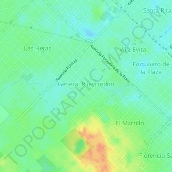
Name: General Pueyrredón topographic map, elevation, terrain.
Average elevation: 92 ft
Minimum elevation: 49 ft
Maximum elevation: 174 ft
Make a donation
Gear up for your next adventure:
As an Amazon Associate, this site earns from qualifying purchases at no extra cost to you.
Other topographic maps
Click on a map to view its topography, its elevation and its terrain.
Mar del Plata
Argentina > Buenos Aires > Mar del Plata
La descendencia del fundador de la ciudad lo lotearon y en las siguientes décadas se crea un barrio residencial del mismo nombre, único por su topografía y características botánicas. Sus principales calles están pavimentadas y su edificación está principalmente compuesta por chalets vacacionales.
Average elevation: 66 ft