
Topeka topographic map
Click on the map to display elevation.
Topeka
Topeka is characterized by a gently rolling terrain that transitions between the floodplain of the Kansas River and the surrounding uplands. The city sits at an elevation of approximately 938 feet (286 meters) above sea level, with its landscape shaped by a mix of prairies and woodlands, particularly in the more northern regions. The Kansas River, flowing through the heart of the city, contributes to the area's topographical variety, creating both low-lying riverbanks and elevated areas such as Burnett's Mound, which offers panoramic views of the city and beyond. The region experiences a humid continental climate, influencing the vegetation and natural features, while the proximity to the Flint Hills to the east adds to the scenic diversity of the landscape.
About this map
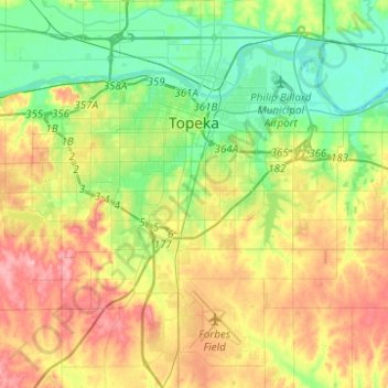
Name: Topeka topographic map, elevation, terrain.
Location: Topeka, Shawnee County, Kansas, United States (38.91719 -95.81226 39.10940 -95.60194)
Average elevation: 991 ft
Minimum elevation: 850 ft
Maximum elevation: 1,194 ft
Shawnee County trails, hiking, mountain biking, running and outdoor activities
Other topographic maps
Click on a map to view its topography, its elevation and its terrain.