
Make a donation
Gear up for your next adventure:
As an Amazon Associate, this site earns from qualifying purchases at no extra cost to you.
Broga topographic map
Click on the map to display elevation.
Make a donation
Gear up for your next adventure:
As an Amazon Associate, this site earns from qualifying purchases at no extra cost to you.
Broga
The hill, approximately 400 m (1,300 ft) in altitude, is notable for its unique appearance as it is rather devoid of trees, which is an uncommon sight amongst the tropical rainforests surrounding the region. Cogongrass typically dominates the summit area. Remnants of burnt out tree trunks indicate that the area may have been ravaged by a forest fire and the trees did not regrow.
Make a donation
Gear up for your next adventure:
As an Amazon Associate, this site earns from qualifying purchases at no extra cost to you.
About this map
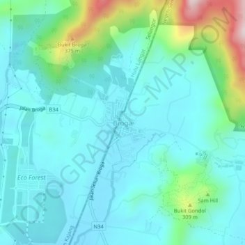
Name: Broga topographic map, elevation, terrain.
Location: Broga, Seremban, Negeri Sembilan, 71750, Malaysia (2.91660 101.89120 2.95660 101.93120)
Average elevation: 463 ft
Minimum elevation: 164 ft
Maximum elevation: 1,706 ft
Make a donation
Gear up for your next adventure:
As an Amazon Associate, this site earns from qualifying purchases at no extra cost to you.