
Make a donation
Gear up for your next adventure:
As an Amazon Associate, this site earns from qualifying purchases at no extra cost to you.
Viveros topographic map
Click on the map to display elevation.
Make a donation
Gear up for your next adventure:
As an Amazon Associate, this site earns from qualifying purchases at no extra cost to you.
About this map
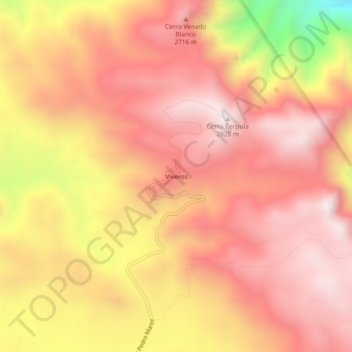
Name: Viveros topographic map, elevation, terrain.
Location: Viveros, Municipio de Ensenada, Baja California, México (31.01758 -115.49063 31.05758 -115.45063)
Average elevation: 8,307 ft
Minimum elevation: 6,329 ft
Maximum elevation: 9,255 ft
Make a donation
Gear up for your next adventure:
As an Amazon Associate, this site earns from qualifying purchases at no extra cost to you.
Other topographic maps
Click on a map to view its topography, its elevation and its terrain.
Rodolfo Sánchez Taboada ( Maneadero )
México > Baja California > Municipio de Ensenada
Average elevation: 171 ft
Make a donation
Gear up for your next adventure:
As an Amazon Associate, this site earns from qualifying purchases at no extra cost to you.