
Make a donation
Gear up for your next adventure:
As an Amazon Associate, this site earns from qualifying purchases at no extra cost to you.
Tremoleto topographic map
Click on the map to display elevation.
Make a donation
Gear up for your next adventure:
As an Amazon Associate, this site earns from qualifying purchases at no extra cost to you.
About this map
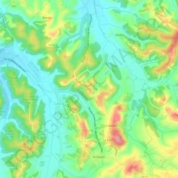
Name: Tremoleto topographic map, elevation, terrain.
Location: Tremoleto, Crespina Lorenzana, Pisa, Toscana, 56042, Italia (43.52446 10.51657 43.56446 10.55657)
Average elevation: 230 ft
Minimum elevation: 98 ft
Maximum elevation: 466 ft
Make a donation
Gear up for your next adventure:
As an Amazon Associate, this site earns from qualifying purchases at no extra cost to you.
Other topographic maps
Click on a map to view its topography, its elevation and its terrain.
Orciano Pisano
(Attilio Zuccagni-Orlandini, Indicatore topografico della Toscana granducale (1856))
Average elevation: 302 ft
Make a donation
Gear up for your next adventure:
As an Amazon Associate, this site earns from qualifying purchases at no extra cost to you.