
Ward 8 topographic map
Click on the map to display elevation.
About this map
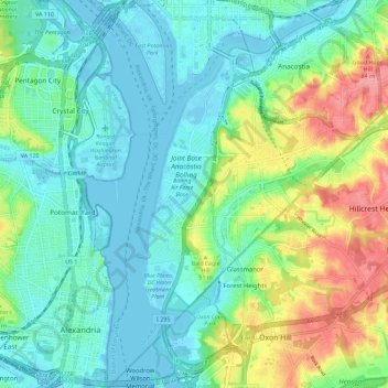
Name: Ward 8 topographic map, elevation, terrain.
Location: Ward 8, Washington, District of Columbia, United States (38.79163 -77.04631 38.88054 -76.96235)
Average elevation: 85 ft
Minimum elevation: -13 ft
Maximum elevation: 305 ft
District of Columbia trails, hiking, mountain biking, running and outdoor activities
Other topographic maps
Click on a map to view its topography, its elevation and its terrain.
United States National Arboretum
United States > District of Columbia > Washington
Average elevation: 69 ft
United States National Arboretum
United States > District of Columbia > Washington
Average elevation: 69 ft