
Thank you for supporting this site ❤️
Make a donation
Make a donation
Gear up for your next adventure:
As an Amazon Associate, this site earns from qualifying purchases at no extra cost to you.
Bivels topographic map
Click on the map to display elevation.
Thank you for supporting this site ❤️
Make a donation
Make a donation
Gear up for your next adventure:
As an Amazon Associate, this site earns from qualifying purchases at no extra cost to you.
About this map
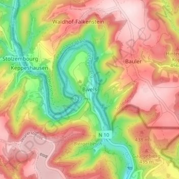
Name: Bivels topographic map, elevation, terrain.
Location: Bivels, Putscheid, Canton Vianden, 9453, Luxembourg (49.93879 6.17159 49.97879 6.21159)
Average elevation: 1,220 ft
Minimum elevation: 666 ft
Maximum elevation: 1,670 ft
Thank you for supporting this site ❤️
Make a donation
Make a donation
Gear up for your next adventure:
As an Amazon Associate, this site earns from qualifying purchases at no extra cost to you.