
Thank you for supporting this site ❤️
Make a donation
Make a donation
Gear up for your next adventure:
As an Amazon Associate, this site earns from qualifying purchases at no extra cost to you.
Brandhoek topographic map
Click on the map to display elevation.
Thank you for supporting this site ❤️
Make a donation
Make a donation
Gear up for your next adventure:
As an Amazon Associate, this site earns from qualifying purchases at no extra cost to you.
About this map
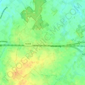
Name: Brandhoek topographic map, elevation, terrain.
Location: Brandhoek, Vlamertinge, Ieper, West-Vlaanderen, 8908, België (50.83515 2.77022 50.87515 2.81022)
Average elevation: 69 ft
Minimum elevation: 30 ft
Maximum elevation: 118 ft
Thank you for supporting this site ❤️
Make a donation
Make a donation
Gear up for your next adventure:
As an Amazon Associate, this site earns from qualifying purchases at no extra cost to you.