Geolocate

Vigolo topographic map

Click on the map to display elevation.

About this map

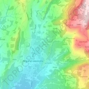
Name: Vigolo topographic map, elevation, terrain.

Location: Vigolo, Negrar di Valpolicella, Verona, Veneto, 37024, Italia (45.51709 10.92746 45.55709 10.96746)

Average elevation: 1,132 ft

Minimum elevation: 476 ft

Maximum elevation: 2,457 ft

Gear up for your next adventure:

🪶Compact Camp Shovel - Folding shovel for campsite tasks
🌧️Backpack Rain Cover - Keep gear dry in wet weather
👟Men's Trail Runners - Lightweight footwear for fast-paced exploration and light hiking
📷Action Camera - Capture your outdoor adventures in HD
GPS Sports Watch - GPS watch for running, hiking and training

As an Amazon Associate, this site earns from qualifying purchases at no extra cost to you.