
Mandav topographic map
Interactive map
Click on the map to display elevation.
About this map
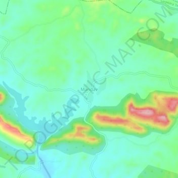
Name: Mandav topographic map, elevation, terrain.
Average elevation: 781 ft
Minimum elevation: 633 ft
Maximum elevation: 1,175 ft
Other topographic maps
Click on a map to view its topography, its elevation and its terrain.
Sagwara
India > Rajasthan > Sagwara Tehsil
Sagwara, Sagwara Tehsil, Dungarpur District, Rajasthan, 314025, India
Average elevation: 581 ft
Kariyana
India > Rajasthan > Sagwara Tehsil
Kariyana, Sagwara Tehsil, Dungarpur District, Rajasthan, 314032, India
Average elevation: 548 ft
Gowari
India > Rajasthan > Sagwara Tehsil
Gowari, Sagwara Tehsil, Dungarpur District, Rajasthan, India
Average elevation: 584 ft
Bheeloora
India > Rajasthan > Sagwara Tehsil > Bheeloora
Bheeloora, Sagwara Tehsil, Dungarpur, Rajasthan, 314031, India
Average elevation: 472 ft