
Make a donation
Gear up for your next adventure:
As an Amazon Associate, this site earns from qualifying purchases at no extra cost to you.
Kabul topographic map
Click on the map to display elevation.
Make a donation
Gear up for your next adventure:
As an Amazon Associate, this site earns from qualifying purchases at no extra cost to you.
Kabul
The modern-day city of Kabul is located high up in a narrow valley between the Hindu Kush, and is bounded by the Kabul River. At an elevation of 1,790 metres (5,873 ft), it is one of the highest capital cities in the world. Kabul is said to be over 3,500 years old, mentioned since at least the time of the Achaemenid Persian Empire. Located at a crossroads in Asia—roughly halfway between Istanbul, Turkey, in the west and Hanoi, Vietnam, in the east—it is situated in a strategic location along the trade routes of Central Asia and South Asia, and was a key destination on the ancient Silk Road; It was traditionally seen as the meeting point between Tartary, India, and Persia. Kabul has also been under the rule of various other dynasties and empires, including the Seleucids, the Kushans, the Hindu Shahis, Western Turks, the Turk Shahis, the Samanids, the Khwarazmians, the Timurids, and the Mongols, among others. In the 16th century, the Mughal Empire used Kabul as an initial summer capital, during which time it increasingly prospered and increased in significance. It briefly came under the control of the Afsharids following Nader Shah's invasion of India, until finally becoming coming under local rule by the Afghan Empire in 1747; Kabul became the capital of Afghanistan in 1776, during the reign of Timur Shah Durrani (a son of Ahmad Shah Durrani). In the 19th century, the city was occupied by the British, but after establishing foreign relations and agreements, they were compelled to withdraw all forces from Afghanistan and returned to British India.
Make a donation
Gear up for your next adventure:
As an Amazon Associate, this site earns from qualifying purchases at no extra cost to you.
About this map
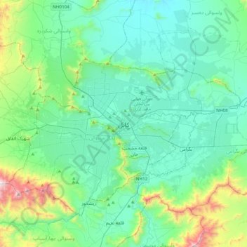
Name: Kabul topographic map, elevation, terrain.
Location: Kabul, Kabul District, Kabul Province, 1001, Afghanistan (34.36664 69.02491 34.68664 69.34491)
Average elevation: 6,362 ft
Minimum elevation: 5,581 ft
Maximum elevation: 9,882 ft
Make a donation
Gear up for your next adventure:
As an Amazon Associate, this site earns from qualifying purchases at no extra cost to you.
Other topographic maps
Click on a map to view its topography, its elevation and its terrain.