
Thank you for supporting this site ❤️
Make a donation
Make a donation
Gear up for your next adventure:
As an Amazon Associate, this site earns from qualifying purchases at no extra cost to you.
Ossogne topographic map
Click on the map to display elevation.
Thank you for supporting this site ❤️
Make a donation
Make a donation
Gear up for your next adventure:
As an Amazon Associate, this site earns from qualifying purchases at no extra cost to you.
About this map
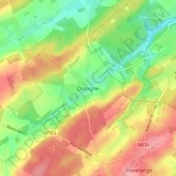
Name: Ossogne topographic map, elevation, terrain.
Location: Ossogne, Havelange, Dinant, Namur, Wallonie, 5353, Belgique (50.38570 5.20122 50.42570 5.24122)
Average elevation: 850 ft
Minimum elevation: 676 ft
Maximum elevation: 1,033 ft
Thank you for supporting this site ❤️
Make a donation
Make a donation
Gear up for your next adventure:
As an Amazon Associate, this site earns from qualifying purchases at no extra cost to you.