Geolocate

Maimbung topographic map

Click on the map to display elevation.

About this map

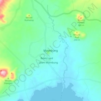
Name: Maimbung topographic map, elevation, terrain.

Location: Maimbung, Sulu, Zamboanga Peninsula, Philippines (5.91544 120.97715 5.99544 121.05715)

Average elevation: 249 ft

Minimum elevation: 0 ft

Maximum elevation: 1,319 ft

Other topographic maps

Click on a map to view its topography, its elevation and its terrain.

Lugus Island

Philippines > Sulu

Average elevation: 66 ft

Bambannan Island

Philippines > Sulu

Average elevation: 0 ft

Dammi Island

Philippines > Sulu

Average elevation: 0 ft

Lugus

Philippines > Sulu

Average elevation: 23 ft

Siasi

Philippines > Sulu

Average elevation: 23 ft

Seit Lake

Philippines > Sulu > Old Panamao

Average elevation: 46 ft

North Ubian Island

Philippines > Sulu > Pangutaran

Average elevation: 7 ft

Simisa Island

Philippines > Sulu > Banguingui

Average elevation: 7 ft

Kulassian Island

Philippines > Sulu > Pangutaran

Average elevation: 0 ft

Jolo Island

Philippines > Sulu

Average elevation: 92 ft

Patikul

Philippines > Sulu

Average elevation: 164 ft

Pangutaran

Philippines > Sulu

Average elevation: 13 ft

Siasi Island

Philippines > Sulu > Siasi

Average elevation: 154 ft

Siasi

Philippines > Sulu

Average elevation: 23 ft

Gear up for your next adventure:

🥩Freeze-Dried Meals - Nutritious and lightweight food for remote expeditions
🍳Camping Cook Set - Complete cookware for outdoor meals
🦟Ultrasonic Repellers - Create a bug-free zone at your camp or rest stop
📦Gear Storage Bags - Organize and protect outdoor equipment
📖Nature Tracking Books - Learn to track wildlife and terrain

As an Amazon Associate, this site earns from qualifying purchases at no extra cost to you.