
Colonia Independencia, Planta Urbana topographic map
Interactive map
Click on the map to display elevation.
About this map
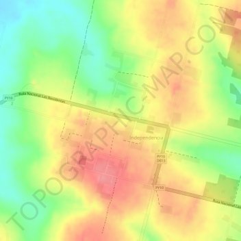
Name: Colonia Independencia, Planta Urbana topographic map, elevation, terrain.
Average elevation: 686 ft
Minimum elevation: 509 ft
Maximum elevation: 820 ft
Die Landschaft ist geprägt durch das Gebirge Cordillera del Ybytyruzú, das teilweise in diesem Distrikt liegt. Hier befindet sich auch der zweithöchsten Berg Paraguays, der Akati mit einer Höhe von 600 m. Es gibt viele Bäche und Wasserfälle, darunter der bekannte Salto Suizo (Schweizer Wasserfall).
Other topographic maps
Click on a map to view its topography, its elevation and its terrain.
Yataity del Guairá
Paraguay > Guairá > Yataity del Guairá
Yataity del Guairá, Guairá, Región Oriental, Paraguay
Average elevation: 443 ft
Villarrica
Paraguay > Guairá > Villarrica
Villarrica, Guairá, Región Oriental, 5000, Paraguay
Average elevation: 525 ft