
Iturbe topographic map
Interactive map
Click on the map to display elevation.
About this map
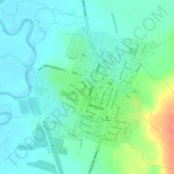
Name: Iturbe topographic map, elevation, terrain.
Location: Iturbe, Guairá, Región Oriental, Paraguay (-26.06336 -56.49777 -26.04437 -56.47503)
Average elevation: 348 ft
Minimum elevation: 295 ft
Maximum elevation: 469 ft
Other topographic maps
Click on a map to view its topography, its elevation and its terrain.
Colonia Independencia, Planta Urbana
Colonia Independencia, Planta Urbana, Guairá, Región Oriental, Paraguay
Average elevation: 686 ft
Yataity del Guairá
Paraguay > Guairá > Yataity del Guairá
Yataity del Guairá, Guairá, Región Oriental, Paraguay
Average elevation: 443 ft
Villarrica
Paraguay > Guairá > Villarrica
Villarrica, Guairá, Región Oriental, 5000, Paraguay
Average elevation: 525 ft