Geolocate

Buffalo topographic map

Click on the map to display elevation.

About this map

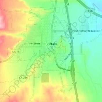
Name: Buffalo topographic map, elevation, terrain.

Location: Buffalo, Johnson County, Wyoming, 82834, United States (44.32459 -106.75061 44.36501 -106.68443)

Average elevation: 4,715 ft

Minimum elevation: 4,505 ft

Maximum elevation: 5,059 ft

Johnson County trails, hiking, mountain biking, running and outdoor activities

Other topographic maps

Click on a map to view its topography, its elevation and its terrain.

Gardner Mountain

United States > Wyoming > Johnson County

Average elevation: 6,880 ft

Gear up for your next adventure:

👖Convertible Hiking Pants - Versatile zip-off pants for changing altitudes and temperatures
📶Satellite Messenger - Communication device off‑grid
🧣Hiking Neck Gaiter - Multi‑use neck protection for outdoor weather
🧦Hiking Socks - Comfortable socks to prevent blisters on long hikes
🌡️Handheld Weather Meters - Measure wind, temp, and pressure for safe mountain travel

As an Amazon Associate, this site earns from qualifying purchases at no extra cost to you.