
Thank you for supporting this site ❤️
Make a donation
Make a donation
Gear up for your next adventure:
As an Amazon Associate, this site earns from qualifying purchases at no extra cost to you.
Yelverton topographic map
Click on the map to display elevation.
Thank you for supporting this site ❤️
Make a donation
Make a donation
Gear up for your next adventure:
As an Amazon Associate, this site earns from qualifying purchases at no extra cost to you.
About this map
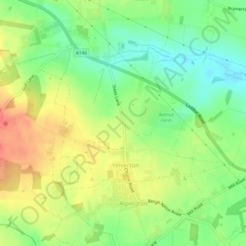
Name: Yelverton topographic map, elevation, terrain.
Location: Yelverton, South Norfolk, Norfolk, England, United Kingdom (52.56637 1.36819 52.58364 1.40002)
Average elevation: 115 ft
Minimum elevation: 33 ft
Maximum elevation: 200 ft
Thank you for supporting this site ❤️
Make a donation
Make a donation
Gear up for your next adventure:
As an Amazon Associate, this site earns from qualifying purchases at no extra cost to you.
Other topographic maps
Click on a map to view its topography, its elevation and its terrain.
Poringland Wood
United Kingdom > England > Norfolk > South Norfolk > Framingham Earl
Average elevation: 164 ft