Geolocate

Thomson topographic map

Click on the map to display elevation.

About this map

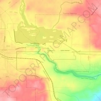
Name: Thomson topographic map, elevation, terrain.

Location: Thomson, Carlton, Carlton County, Minnesota, United States (46.64355 -92.41797 46.68355 -92.37797)

Average elevation: 1,073 ft

Minimum elevation: 791 ft

Maximum elevation: 1,234 ft

Carlton County trails, hiking, mountain biking, running and outdoor activities

Other topographic maps

Click on a map to view its topography, its elevation and its terrain.

Thomson Reservoir

United States > Minnesota > Carlton County > Carlton

Average elevation: 1,073 ft

Gear up for your next adventure:

🧼Biodegradable Camping Soap - Eco‑friendly soap for outdoor hygiene
🏕️Family Camping Gear - Essentials for group camping trips
🩹Survival Bandages - High‑quality bandages for emergencies
💧Water Purification System - Clean water on the trail with reliable purifiers
🛡️Bear Spray Outdoor - Protection in bear country hikes

As an Amazon Associate, this site earns from qualifying purchases at no extra cost to you.