Geolocate

Baldwin City topographic map

Click on the map to display elevation.

About this map

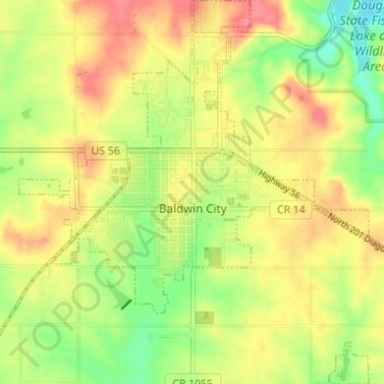
Name: Baldwin City topographic map, elevation, terrain.

Location: Baldwin City, Douglas County, Kansas, United States (38.75298 -95.21429 38.80099 -95.15812)

Average elevation: 1,060 ft

Minimum elevation: 938 ft

Maximum elevation: 1,165 ft

Douglas County trails, hiking, mountain biking, running and outdoor activities

Other topographic maps

Click on a map to view its topography, its elevation and its terrain.

Potter Lake

United States > Kansas > Douglas County > Lawrence

Average elevation: 932 ft

Lawrence

United States > Kansas > Douglas County > Lawrence

Downtown Lawrence is located at 38°58′18″N 95°14′7″W / 38.97167°N 95.23528°W / 38.97167; -95.23528 (38.959902, −95.253199), approximately 25 miles (40 kilometers) east of Topeka, and 35 mi (56 km) west of Kansas City, Kansas. Though Lawrence has a designated elevation of 866 feet (264…

Average elevation: 928 ft

Gear up for your next adventure:

🦶Hiking Gaiters - Keep debris and water out of your boots
📷Action Camera - Capture your outdoor adventures in HD
🧣Merino Neck Gaiters - Multi-functional headwear for wind and sun protection
🧺Microfiber Travel Towels - Compact and fast-drying towels for trail use
📶Vehicle Signal Boosters - Improve reception in rural areas while driving to trailheads

As an Amazon Associate, this site earns from qualifying purchases at no extra cost to you.