
Make a donation
Gear up for your next adventure:
As an Amazon Associate, this site earns from qualifying purchases at no extra cost to you.
Sites topographic map
Click on the map to display elevation.
Make a donation
Gear up for your next adventure:
As an Amazon Associate, this site earns from qualifying purchases at no extra cost to you.
Sites
Sites is an unincorporated community in Colusa County, California, United States. It lies at an elevation of 299 feet (91 m). Its ZIP code is 95979 and its area code is 530.
Make a donation
Gear up for your next adventure:
As an Amazon Associate, this site earns from qualifying purchases at no extra cost to you.
About this map
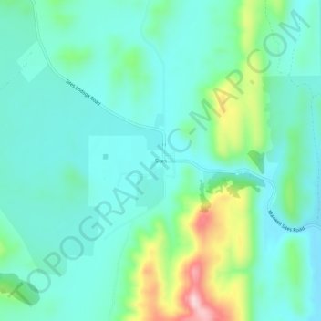
Name: Sites topographic map, elevation, terrain.
Location: Sites, Colusa County, California, United States (39.28878 -122.35859 39.32878 -122.31859)
Average elevation: 430 ft
Minimum elevation: 207 ft
Maximum elevation: 1,178 ft
Colusa County trails, hiking, mountain biking, running and outdoor activities
Make a donation
Gear up for your next adventure:
As an Amazon Associate, this site earns from qualifying purchases at no extra cost to you.
Other topographic maps
Click on a map to view its topography, its elevation and its terrain.