
Jilotepec topographic map
Interactive map
Click on the map to display elevation.
About this map
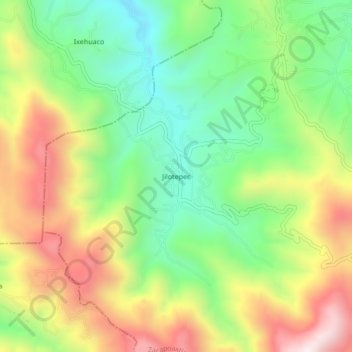
Name: Jilotepec topographic map, elevation, terrain.
Location: Jilotepec, Zacapoaxtla, Puebla, México (19.78000 -97.64861 19.82000 -97.60861)
Average elevation: 7,205 ft
Minimum elevation: 6,171 ft
Maximum elevation: 8,596 ft
Other topographic maps
Click on a map to view its topography, its elevation and its terrain.
Zacapoaxtla
México > Puebla > Zacapoaxtla
Zacapoaxtla, Puebla, 73680, México
Average elevation: 6,362 ft
Comaltepec
México > Puebla > Zacapoaxtla
Comaltepec, Zacapoaxtla, Puebla, 73680, México
Average elevation: 6,401 ft