
Thank you for supporting this site ❤️
Make a donation
Make a donation
Gear up for your next adventure:
As an Amazon Associate, this site earns from qualifying purchases at no extra cost to you.
Comaltepec topographic map
Click on the map to display elevation.
Thank you for supporting this site ❤️
Make a donation
Make a donation
Gear up for your next adventure:
As an Amazon Associate, this site earns from qualifying purchases at no extra cost to you.
About this map
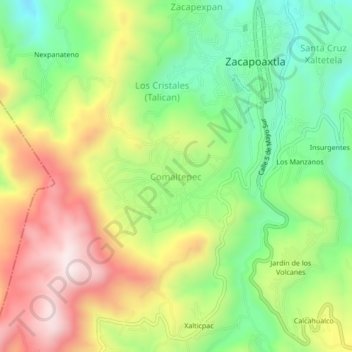
Name: Comaltepec topographic map, elevation, terrain.
Location: Comaltepec, Zacapoaxtla, Puebla, 73680, México (19.84000 -97.61861 19.88000 -97.57861)
Average elevation: 6,401 ft
Minimum elevation: 5,456 ft
Maximum elevation: 7,602 ft
Thank you for supporting this site ❤️
Make a donation
Make a donation
Gear up for your next adventure:
As an Amazon Associate, this site earns from qualifying purchases at no extra cost to you.