Geolocate

Brooks topographic map

Click on the map to display elevation.

About this map

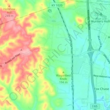
Name: Brooks topographic map, elevation, terrain.

Location: Brooks, Bullitt County, Kentucky, 40109, United States (38.03565 -85.74555 38.08717 -85.69930)

Average elevation: 620 ft

Minimum elevation: 453 ft

Maximum elevation: 919 ft

Bullitt County trails, hiking, mountain biking, running and outdoor activities

Other topographic maps

Click on a map to view its topography, its elevation and its terrain.

Phelps Knob

United States > Kentucky > Bullitt County

Average elevation: 528 ft

Bernheim Forest

United States > Kentucky > Bullitt County

Average elevation: 755 ft

Dawson Knob

United States > Kentucky > Bullitt County

Average elevation: 666 ft

Pitts Point

United States > Kentucky > Bullitt County

Average elevation: 509 ft

Gear up for your next adventure:

🏫Relief Map Kits - Hands-on tools for teaching landforms and elevation
⛑️Personal Locator Beacon - Safety beacon for emergencies
📶Satellite Messenger - Communication device off‑grid
🧷Carabiner Set - Durable clips for gear attachment
🔋Rechargeable Batteries - Power up your outdoor devices

As an Amazon Associate, this site earns from qualifying purchases at no extra cost to you.