Geolocate

Maud topographic map

Click on the map to display elevation.

About this map

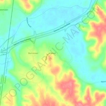
Name: Maud topographic map, elevation, terrain.

Location: Maud, Colbert County, Alabama, United States (34.62315 -88.12976 34.66315 -88.08976)

Average elevation: 518 ft

Minimum elevation: 417 ft

Maximum elevation: 696 ft

Colbert County trails, hiking, mountain biking, running and outdoor activities

Other topographic maps

Click on a map to view its topography, its elevation and its terrain.

Cherokee

United States > Alabama > Colbert County

Average elevation: 541 ft

Littleville

United States > Alabama > Colbert County

Average elevation: 689 ft

Sheffield

United States > Alabama > Colbert County

Average elevation: 495 ft

Gear up for your next adventure:

🧥Waterproof Jacket for Hiking - Breathable and rugged rain jacket for outdoor excursions
🚁Photography Drones - Capture stunning aerial views of landforms and topography
📌Outdoor GPS Map App - Apps and devices for digital topographic navigation
🛰️Handheld GPS Units - Professional satellite navigators for precise backcountry mapping
❄️Traction Cleats - Prevent slips on icy trails during winter hikes

As an Amazon Associate, this site earns from qualifying purchases at no extra cost to you.