Geolocate

Sanare topographic map

Click on the map to display elevation.

About this map

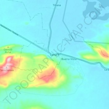
Name: Sanare topographic map, elevation, terrain.

Location: Sanare, Parroquia Chichiriviche, Municipio Monseñor Iturriza, Estado Falcón, Venezuela (10.83198 -68.42354 10.91198 -68.34354)

Average elevation: 174 ft

Minimum elevation: -10 ft

Maximum elevation: 1,165 ft

Other topographic maps

Click on a map to view its topography, its elevation and its terrain.

Gear up for your next adventure:

🪑Portable Camp Table - Compact table for campsite meals
👟Men's Trail Runners - Lightweight footwear for fast-paced exploration and light hiking
🗺️Topographic Maps - Detailed topo maps for hiking, exploring and outdoor navigation
🚪Portable Camp Chair - Foldable chair for comfort at camp
🧴Hand Sanitizer - Keep hands clean while hiking

As an Amazon Associate, this site earns from qualifying purchases at no extra cost to you.