Geolocate

Springfield topographic map

Interactive map

Click on the map to display elevation.

About this map

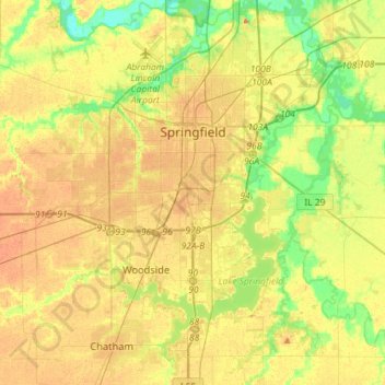
Name: Springfield topographic map, elevation, terrain.

Location: Springfield, Sangamon County, Illinois, United States (39.65366 -89.77318 39.87417 -89.56851)

Average elevation: 584 ft

Minimum elevation: 499 ft

Maximum elevation: 659 ft

The city is at an elevation of 558 feet (170 m) above sea level. According to the 2010 census, Springfield has a total area of 65.764 square miles (170.33 km2), of which 59.48 square miles (154.05 km2) (or 90.44%) is land and 6.284 square miles (16.28 km2) (or 9.56%) is water. The city is located in the Lower Illinois River Basin, in a large area known as Till Plain. Sangamon County, and the city of Springfield, are in the Springfield Plain subsection of Till Plain. The Plain is underlain by glacial till that was deposited by a large continental ice sheet that repeatedly covered the area during the Illinoian Stage.

Wikipedia (CC-BY-SA 3.0)

Other topographic maps

Click on a map to view its topography, its elevation and its terrain.

Jerome

United States > Illinois > Sangamon County

Jerome, Sangamon County, Illinois, United States

Average elevation: 607 ft

Pawnee

United States > Illinois > Sangamon County

Pawnee, Sangamon County, Illinois, United States

Average elevation: 600 ft

Divernon

United States > Illinois > Sangamon County

Divernon, Sangamon County, Illinois, 62530, United States

Average elevation: 614 ft

Grandview

United States > Illinois > Sangamon County

Grandview, Sangamon County, Illinois, United States

Average elevation: 600 ft

Auburn

United States > Illinois > Sangamon County

Auburn, Sangamon County, Illinois, 62615, United States

Average elevation: 627 ft

Chatham

United States > Illinois > Sangamon County

Chatham, Sangamon County, Illinois, 62629, United States

Average elevation: 600 ft

Bates

United States > Illinois > Sangamon County

Bates, Sangamon County, Illinois, 62670, United States

Average elevation: 636 ft

Rochester

United States > Illinois > Sangamon County > Rochester

Rochester, Sangamon County, Illinois, United States

Average elevation: 574 ft

Williamsville

United States > Illinois > Sangamon County > Williamsville

Williamsville, Sangamon County, Illinois, 62693, United States

Average elevation: 581 ft

Buffalo

United States > Illinois > Sangamon County > Buffalo

Buffalo, Sangamon County, Illinois, United States

Average elevation: 604 ft

Riverton

United States > Illinois > Sangamon County

Riverton, Sangamon County, Illinois, 62651, United States

Average elevation: 561 ft