
Make a donation
Gear up for your next adventure:
As an Amazon Associate, this site earns from qualifying purchases at no extra cost to you.
Circle Pines topographic map
Click on the map to display elevation.
Make a donation
Gear up for your next adventure:
As an Amazon Associate, this site earns from qualifying purchases at no extra cost to you.
About this map
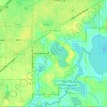
Name: Circle Pines topographic map, elevation, terrain.
Location: Circle Pines, Anoka County, Minnesota, United States (45.12421 -93.16369 45.15323 -93.13774)
Average elevation: 902 ft
Minimum elevation: 869 ft
Maximum elevation: 925 ft
Anoka County trails, hiking, mountain biking, running and outdoor activities
Make a donation
Gear up for your next adventure:
As an Amazon Associate, this site earns from qualifying purchases at no extra cost to you.
Other topographic maps
Click on a map to view its topography, its elevation and its terrain.
Make a donation
Gear up for your next adventure:
As an Amazon Associate, this site earns from qualifying purchases at no extra cost to you.
Lino Lakes
United States > Minnesota > Anoka County > Lino Lakes > Lino Lakes
Average elevation: 899 ft
Thompson Heights
United States > Minnesota > Anoka County > Coon Rapids > Thompson Heights
Average elevation: 866 ft
Make a donation
Gear up for your next adventure:
As an Amazon Associate, this site earns from qualifying purchases at no extra cost to you.