
Thank you for supporting this site ❤️
Make a donation
Make a donation
Gear up for your next adventure:
As an Amazon Associate, this site earns from qualifying purchases at no extra cost to you.
Nepal topographic map
Click on the map to display elevation.
Thank you for supporting this site ❤️
Make a donation
Make a donation
Gear up for your next adventure:
As an Amazon Associate, this site earns from qualifying purchases at no extra cost to you.
About this map
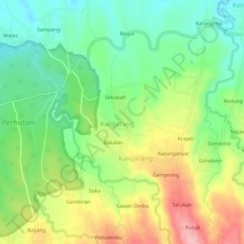
Name: Nepal topographic map, elevation, terrain.
Location: Nepal, Kaligarang, Jepara, Central Java, Java, Indonesia (-6.51555 110.82402 -6.47555 110.86402)
Average elevation: 459 ft
Minimum elevation: 249 ft
Maximum elevation: 778 ft
Thank you for supporting this site ❤️
Make a donation
Make a donation
Gear up for your next adventure:
As an Amazon Associate, this site earns from qualifying purchases at no extra cost to you.