
Lac Crooks topographic map
Interactive map
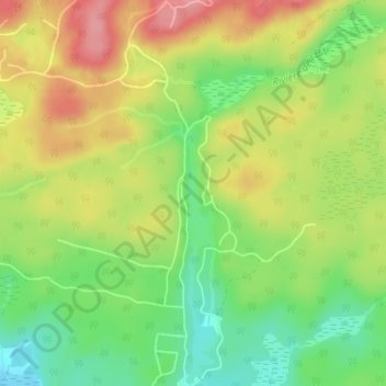
Click on the map to display elevation.
About this map
Name: Lac Crooks topographic map, elevation, terrain.
Average elevation: 673 ft
Minimum elevation: 505 ft
Maximum elevation: 853 ft
Other topographic maps
Click on a map to view its topography, its elevation and its terrain.
Lac Lentol
Canada > Quebec > Brownsburg-Chatham
Lac Lentol, Chemin de Sorel, Brownsburg-Chatham, Argenteuil, Laurentides, Quebec, J8G 3A4, Canada
Average elevation: 741 ft
Lac Carillon
Canada > Quebec > Brownsburg-Chatham > Dalesville
Lac Carillon, Rue du Progrès, Dalesville, Brownsburg-Chatham, Argenteuil, Laurentides, Quebec, J8G 3C4, Canada
Average elevation: 607 ft
Lac Rainbow
Canada > Quebec > Brownsburg-Chatham
Lac Rainbow, Rue de l'Arc-en-Ciel, Brownsburg-Chatham, Argenteuil, Laurentides, Quebec, J8G 1E4, Canada
Average elevation: 896 ft
Petit lac Grenville
Canada > Quebec > Brownsburg-Chatham
Petit lac Grenville, Chemin d'Andernach, Brownsburg-Chatham, Argenteuil, Laurentides, Quebec, J8G 1E4, Canada
Average elevation: 968 ft