
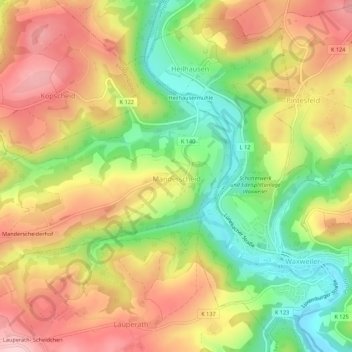
Manderscheid topographic map
Interactive map
Click on the map to display elevation.
About this map
Name: Manderscheid topographic map, elevation, terrain.
Average elevation: 1,421 ft
Minimum elevation: 1,060 ft
Maximum elevation: 1,755 ft
Der Ort liegt im Islek, einem westlichen Höhenzug der Eifel. Die Gemeinde zieht sich etwa 3 km in Ost-West-Richtung entlang der Kreisstraße 140 hin. Zu Manderscheid gehören auch der Weiler Manderscheiderhof und der Wohnplatz Heilhausermühle.[2]
Other topographic maps
Click on a map to view its topography, its elevation and its terrain.
Hüttingen an der Kyll
Deutschland > Rheinland-Pfalz > Eifelkreis Bitburg-Prüm
Hüttingen an der Kyll, Bitburger Land, Eifelkreis Bitburg-Prüm, Rheinland-Pfalz, Deutschland
Average elevation: 971 ft
Wallendorf
Deutschland > Rheinland-Pfalz > Eifelkreis Bitburg-Prüm
Wallendorf, Südeifel, Eifelkreis Bitburg-Prüm, Rheinland-Pfalz, Deutschland
Average elevation: 971 ft
Meckel
Deutschland > Rheinland-Pfalz > Eifelkreis Bitburg-Prüm
Meckel, Bitburger Land, Eifelkreis Bitburg-Prüm, Rheinland-Pfalz, Deutschland
Average elevation: 1,106 ft
Daleiden
Deutschland > Rheinland-Pfalz > Eifelkreis Bitburg-Prüm
Daleiden, Arzfeld, Eifelkreis Bitburg-Prüm, Rheinland-Pfalz, 54689, Deutschland
Average elevation: 1,414 ft
Ferschweiler
Deutschland > Rheinland-Pfalz > Eifelkreis Bitburg-Prüm
Ferschweiler, Südeifel, Eifelkreis Bitburg-Prüm, Rheinland-Pfalz, Deutschland
Average elevation: 1,135 ft
Rodershausen
Deutschland > Rheinland-Pfalz > Eifelkreis Bitburg-Prüm > Rodershausen
Rodershausen, Südeifel, Eifelkreis Bitburg-Prüm, Rheinland-Pfalz, Deutschland
Average elevation: 1,453 ft