
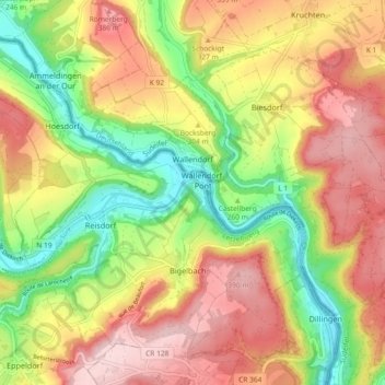
Wallendorf topographic map
Interactive map
Click on the map to display elevation.
About this map
Name: Wallendorf topographic map, elevation, terrain.
Average elevation: 971 ft
Minimum elevation: 561 ft
Maximum elevation: 1,358 ft
Other topographic maps
Click on a map to view its topography, its elevation and its terrain.
Hüttingen an der Kyll
Deutschland > Rheinland-Pfalz > Eifelkreis Bitburg-Prüm
Hüttingen an der Kyll, Bitburger Land, Eifelkreis Bitburg-Prüm, Rheinland-Pfalz, Deutschland
Average elevation: 971 ft
Meckel
Deutschland > Rheinland-Pfalz > Eifelkreis Bitburg-Prüm
Meckel, Bitburger Land, Eifelkreis Bitburg-Prüm, Rheinland-Pfalz, Deutschland
Average elevation: 1,106 ft
Daleiden
Deutschland > Rheinland-Pfalz > Eifelkreis Bitburg-Prüm
Daleiden, Arzfeld, Eifelkreis Bitburg-Prüm, Rheinland-Pfalz, 54689, Deutschland
Average elevation: 1,414 ft
Ferschweiler
Deutschland > Rheinland-Pfalz > Eifelkreis Bitburg-Prüm
Ferschweiler, Südeifel, Eifelkreis Bitburg-Prüm, Rheinland-Pfalz, Deutschland
Average elevation: 1,135 ft
Manderscheid
Deutschland > Rheinland-Pfalz > Eifelkreis Bitburg-Prüm
Manderscheid, Arzfeld, Eifelkreis Bitburg-Prüm, Rheinland-Pfalz, Deutschland
Average elevation: 1,421 ft
Rodershausen
Deutschland > Rheinland-Pfalz > Eifelkreis Bitburg-Prüm > Rodershausen
Rodershausen, Südeifel, Eifelkreis Bitburg-Prüm, Rheinland-Pfalz, Deutschland
Average elevation: 1,453 ft